- Nike Giannis Immortality 3 - Nike Jordan Sport DNA Svarta mjukisbyxor i fleece med heltäckande logga - RvceShops
- dolce gabbana portofino lace up sneakers item
- Axel Arigato Men's Bird Tape Sneakers in Cremino, women and kids • Hanbags and accessories
- The 25 Best Air Force basketball 1 Colourways of All Time , IetpShops , Nike Swoosh logo embroidered fleece shorts
- adidas superstar heren groen shoes sale india 2018
- new air jordan 1 high og osb dian blue chill white cd0463 401
- eastbay restock large amount air jordans
- Air Jordan 1 Mid Bred 554724 074 2020 Release Date 4
- Air Jordan 1 Blue Chill Womens CD0461 401 Release Date 4
- nike air force 1 low white gold dc2181 100 release date info
- Home
- News and analysis
- Info hubs
- Events
- Video
- Case Studies
- About us
- Magazine
- Advertising
Produced for the industry by the Association for Consultancy and Engineering
News
How advancing technology is allowing Network Rail to view rail like never before
Men and women walking up and down tracks across the country to carry out routine maintenance and lower-level surveying jobs may soon become a thing of the past thanks to a national intelligence model which is helping engineers and planners look at railways in a way they have never been able to do before.
The Geo-RINM viewer (GRV) is a central part of Network Rail’s preparation and maintenance work at a time when the organisation continues to plough ahead with a £38bn upgrade investment program designed to cope with the millions of daily journeys.
The GRV is the brainchild of Network Rail and Infrastructure Intelligence was invited to the rail operator’s demonstration of the super high-res survey to see first-hand how the forward-thinking resource which scours 20,000 miles of UK rail routes was enabling the company to overcome obstacles on a day-to-day basis.
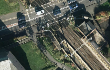
Staff use the viewer to view thousands of miles of railways more clearly via aerial data which produces high-resolution images that can be later extracted and used for 3D modelling. The digitalised operation allows employees to gain better visibility of tracks, level crossings or overhead lines. It’s all part of how Network Rail is moving towards the ‘predict and prevent’ strategy instead of a ‘find and fix’ method. Project managers describe the tool as an “incredibly powerful” asset which increases efficiency and reduces the element of hazard for teams working on tracks across the UK.
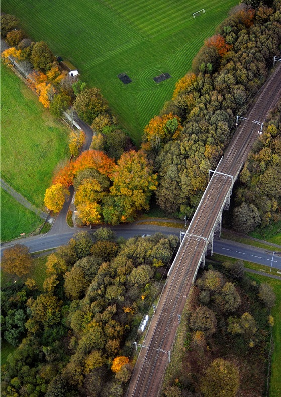
Back in 2014, Network Rail conducted and completed an aerial survey of all the 16,000km of its routes as part of the Offering Rail Better Information Services (ORBIS) programme. As part of this aerial survey over 250 helicopter flights were completed in one flying season, capturing over 110,000 individual image tiles. Since then, another 4,000km of data has been collected as the routes continue to expand. The £330m five-year programme aimed at creating a detailed digital model of the country’s network is one of Europe’s largest rail infrastructure transformation programmes. The plan which originated in 2012, is predicted to save approximately £1bn by 2025.
The aerial surveys record at a height of 250m with the data then placed in the hands of engineers who use it to plan projects by checking anything from vegetation clearance to bridge demolition and new station builds. Ultimately, the data provides staff with a comprehensive aerial survey of Network Rail's assets.
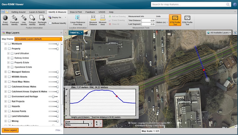
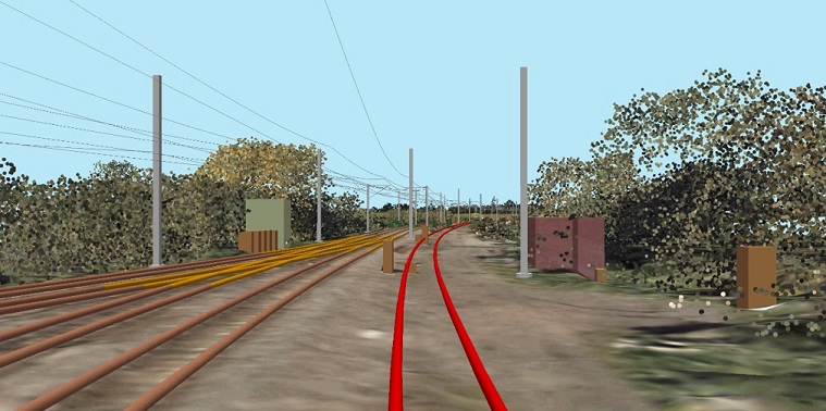
There are three types of imagery in the GRV: Orthophoto RGB, digital surface model (DSM) and the digital terrain model (DTM). RGB is a representation of the real world showing ground features at a resolution of 4cm, offering a massive improvement on former tools like Google Maps and OS imagery which can only reach 20 and 25cm respectively. The other two imagery surveys show users both the height of any features and what the ground itself is doing. The DSM provides elevation measurements for anything from trees and bridges, while the DTM focuses on above ground features like vegetation.
Data collected from air surveys is also key for Network Rail in managing its boundaries with imagery collected 50m either side of the boundary which means the company can be completely sure of who is responsible whenever it may enter liability discussions.
Barry Gleeson, Network rail’s programme manager (BIM), infrastructure projects, said: “The feedback tells us that our users are finding it incredibly valuable to see any part of the network in high-resolution imagery before they even go to site due to the time it can save on track. Now teams can often plan and familiarise themselves with a site before leaving the office. They can identify the hazards, access point and what materials they need just by using the surveys to analyse areas which might possibly present risks.”
To keep ahead of inevitable environmental changes which can have big impacts on rail networks, full national surveys have been staggered for every five years with a refresh every year where required. But to overcome expensive helicopter rides, the ORBIS program has incorporated the use of drones in the sky to provide map data.
Network Rail highlights some of the ways in which the Geo-RINM viewer can benefit staff and clients as follows:
- Measuring assets: The viewer can be used to digitally measure distances and areas and improve decision-making.
- Work site planning: Allows staff to become more familiar and aware of the site before turning up to the site meaning planners have a better chance of identifying safety hazards and thus reducing time spent out on site.
- Boundary management: Data collected 50m either side of Network Rail boundaries allows easier identification of the company’s fencing and posts, among other assets.
- Vegetation management: A more proactive style of management is enabled via the technology with users able to view the height of vegetation and the gradient of any slopes containing trees.
A number of companies connected to the rail network have spoken out about the viewer and how it has transformed the way they work.
Andrew Tustin, station portfolio surveyor for Anglia, said: “The GRV is saving me time and money. I no longer have to travel to stations in the route to gather key information – it’s all accurate and at my fingertips.” David MacLean, a level crossing manager in Inverness, said: “Everyone should be using this – I don’t think people realise how powerful the GRV is. Risk assessments are more accurate and detailed – and safer too, as the data means I can see where steep drops occur and the precise levels of gradients.”
Russ Parker, an incident controller in York, said: “Using the GRV saves a significant amount of time when responding to incidents - I can clarify asset information and exact locations within one streamlined viewer. I also have a clearer awareness of the incident, the assets relevant to it and can provide key location information to response teams and third parties.”
As the GRV has become more advanced and added functionality, data extracted from surveys has been used for future extensive rail projects. Crossrail 2 is one example that taken advantage of the technology available for planning decisions and to supplement public consultations through the form of 3D modelling. After trialling a number of emerging technologies, a pilot scheme proved so successful that bosses behind Crossrail 2 decided to run 3D modelling for the entire route.
Marco Sala, a senior geospatial information technical specialist at Network Rail, said: “3D GIS reality models have provided a new approach to model the physical rail infrastructure using cutting edge technology to visualise it. At the end of March 2017, we completed the production of models and handed over the data to the Crossrail 2 team.”


More from this issue
Tweets
-
 Influential Infrastructure Leaders from around the globe are coming together in Geneva this week, to discuss key is… https://t.co/h3sYcz6xIX
 -
Check out our feature on Hannah Mehr, an award-winning apprentice at @ArupUK. Hannah is keen to promote apprentice… https://t.co/I5RgsjvC9x
-
OUT NOW! Grab yourself a cuppa and enjoy the brand new edition of our digital magazine. https://t.co/mVtPMerNwH… https://t.co/HJdp1No901